Showing posts with label walks. Show all posts

Tuesday, August 2, 2011

Cortalets to Marialles Ridge Route

A fantastic day today. Having seen the Concert for the Sunrise I leave the Cortalets Refuge for The Marialles Refuge not by the normal routes but by the ridge route.

I start my descent from the Crete du Barbet and get my first view of Puig Sec and the ridgeline behind which is partly obscured by mist. This quickly clears.

Looking at the Porteille de Valmanya and Puig Sec (2665m) with the Ridge Behind.

Ascent and descent of the Puig Sec brings me nearer to the ridge which can now be clearly seen.


Puig Del Roc Negre (2714m) and Puig Dels Tres Vents (2731m)

I miss Puig Del Roc Negre but reach the summit of the Puig Dels Tres Vents which offers great views back towards Pic Canigou.

Pic Canigou (2784m) and the Gougs (Lakes) de Cady

The next peak is Puig Roja (2742m) and then the Pic Des Sept Hommes (2651m). From this peak I descend down to the plateau Pla Guillem.

Pla Guillem
On the final approach to the Marialles Refuge and a welcome refreshing drink, I discover an old shepherds shelter - dry stone walls and turf roof!

Old Shepherds Shelter


Pic Bugarach

A circular walk to Pic Bugarach starting and finishing in the village and passing the Cascade de Mathieux and La Fenêtre. 

You start on a section of Sentier Cathare/Cathar Way – a 250 km/ mile footpath which winds its way between Port-la-Nouvelle on the Mediterranean Coast and Foix, between a large number of villages and chateaux with strong links to the Cathars. After 2.5km/ 1.5miles from the village, the path passes above the Cascade des Mathieux. The waterfall cannot been seen from the path so look out for the small sign on your left.  A real hidden treasure.

As the path gets steeper, the trees thin and it becomes necessary to use your hands to scramble up the limestone. La fenêtre/ window is a natural opening in the limestone rock which the path passes behind. After more scrambling, the summit comes into view . 

Summit View From Pic Bugarach
Very windy on the summit as is often the case here. My binoculars help identify the large bird of prey as a vulture. There is a 360° panorama. Not a particularly clear day so the views not as spectacular as they can be.

To the north is the Montagne d'Alaric (30°). To the east two cathar castles – Peyrepertuse (88°) and Quéribus (98°) and the sea 60km away. To the south are the Pyrenees closest to the sea with the unmistakable outline of Pic Canigou (170°). To the west more of the Pyrenees with the Pic St Barthelemy (266°) and closer the hill top village of Rennes-le-Château (306°).

While on the summit I thought about  how  according to some, the end of the Mayan calendar on 21st December 2011 means the end of the world! Except that is for those who are in the vicinity of Bugarach village which will escape the apocolypse apparently. As well as the end of the world, much has been written linking Pic Bugarach to hidden treasure, unidentified flying objects and strange lights etc. It is even said that it inspired Steven Spielberg and his film 'Close Encounters of the Third Kind' although the actual peak in the film is based almost certainly on the Devils Tower in Wyoming.

I found an esoteric geometric pattern carved into the summit rock and later found an identical pattern carved into a large rock close to the descent path.

Esoteric Geometric Pattern Carved Into The Summit Rock
The descent path from the summit soon enters a shady forest of box. Box wood is a hard wood and so heavy it will sink in water ! Lower down beech appear as well offering welcome shade.

'Rams Head'/Beech Roots


Wednesday, June 15, 2011

4 Days Walking With Steve

The end of May saw me put together a 4 day walking trip for Steve from Stoke who flew into Carcassonne from Liverpool . The Orri de Planes which I normally use was not open yet and neither was the Refuge des Camporells so I had to find 2 chambres d'hotes. They were both friendly and looked after us well. I chose walks to suit Steve's fitness level with enough built in flexibility to allow them to be shortened or lengthened depending on how Steve felt on the day.

Day 1 was an excellent example of this. We walked up the Balmeta Valley passing the Balmeta lake and then on through the Llosa Valley and its frozen lakes and snow patches - it being still early in the season. With Steve feeling good  we took the summit option, topping out on the Puig de la Portella Gran. Close to the summit we found Purple Saxifrage (see Record Breaking High Altitude Plants blog entry.) On the descent I saw a Ptarmigan.

Puig de la Portella Gran

Day 2 was a recovery day and I chose to take Steve up to the border with Spain above Osseja. This can be done by car on a forestry track. There was a short walk along the border with plenty of time to relax and cloud watch.

Cloud Watching

Day 3 was spent exploring the Eyne Valley which is world famous for its flowers. Too early in the season to be at its best, there was a fine display of Narcissus and we saw 3 types of Gentianes (Trumpet, Spring and Pyrenean.) As well as a fine display of spring flowers, we saw isard and mouflon. We turned back before the col.

Narcissus

Day 4 was the ascent of Roc Blanc. This was Steve's favourite day. Great alpine scenery - pine forest and lake and 360° views from the summit. 

Looking Toward the Final Col Before the Summit of Roc Blanc


Steve on the Summit of Roc Blanc

The Descent to Lake Laurenti
Had a great few days again with Paul. He produced and adapted an itinerary to suit my needs and abilities to a tee.  The places we stayed were full of character and charm with a really warm welcome. The days suitably challenging but not too much.  Great time - highly recommended - will definitely come again.  Thanks Paul.
Steve  28th May 2011

Wednesday, May 18, 2011

The Alternative Royal Wedding Weekend

How did you spend the Royal Wedding Weekend? Myself and some friends, many old work colleagues from my previous life as a secondary school teacher, spent the time in the Snowdonia mountains, far from the crowds and fuss in London, far even from a television set. Even if there had been a television, there was no electricity in the accommodation to power it. There wasn't even any running water! A special, memorable weekend in so many ways. Thanks to everyone there.

Unusually for North Wales, after a grey, windy start on day 1, the sun shone! My guiding business, Pyrenees Mountain Adventure,  operates in the Eastern Pyrenees near Mont Louis which has one of the best sunshine records in France. This weekend North Wales was trying to compete.

The group chose quieter areas and/or peaks and to a large extent missed the crowds who had also decided to spend the weekend in the mountains. For us, no Snowdon or Tryfan but some great walking and beautiful views. Y Garn and Moelwyn Mawr are two of the best peaks for the views from the summit.

Bristley Ridge with Tryfan and the Crowds Behind


Great Views From the Summit of Y Garn. L to R: Pen yr Ole Wen, Lyn Ogwen, Lyn Idwal, Tryfan, Glyder Fach.

Alternative Descent from Y Garn. Two Hidden Lakes with Tryfan,  Bristley Ridge and the Glyers in the Distance.
Nantley Ridge from the Summit of Moelwyn Mawr

Sunday, March 13, 2011

Frozen Lakes and Conifer Forests

On a recent 2 days spent walking near Lake Bouillouse, the sunny weather for which the Eastern Pyrenees is famous was nowhere to be seen. Snow flurries, gusting winds and biting cold only relented by the afternoon of the second day.

One of the Many Frozen Lakes in the Area


Still, the weather conditions gave the area an Arctic look at times which I enjoyed.

Conditions Gave the Area  an Arctic Feel


I also enjoyed the wind sculpted snow.

Sastrugi - wind sculpted snow


Unfortunately, there were no views from the summit of Tossal Colomer that had been cleared of most of its snow by the wind. I was not able to look across to the Pic Carlit, the highest peak in the Catalan Pyrenees Regional Nature Park and first climbed by the famous Count Henry Russel. Neither was I able to look down on the myriad of lakes for which this particular area of the Park is famous.

Happily, the weather brightened for the descent and I was able to see more of the delightful valley along which I made my approach.

Looking Back at the Final Col Before the Summit (Hidden on the Right)

With the weather hot and sunny for the return to the Bouillouse Dam, I was able to look back at my  snow shoe tracks in the fresh powder snow and in the distance Tossal Colomer

Fresh Tracks and in the Distance Tossal Colomer

Sunday, January 30, 2011

Petit Peric

With the very hot and sunny weather the day of this walk, it was hard to believe it was January. Snow cover was what the avalanche forecast calls 'intermittent', but it was there in sufficient quantities to be able to snowshoe for some of the time.

View of the Petit Peric from the Camporells Refuge
The view from in front of the Camporells Refuge is one of my favourites. I sat in the sun for a long time enjoying the silence and view across the frozen lake towards the smaller of the twin Peric peaks.

Later in the day, I enjoyed a late lunch on the summit of the Petit Peric.

View from the Petit Peric summmit
“Being in nature, we are balanced, made well, reconnected with the Primordial” - Andreas Cohr

Sunday, November 7, 2010

Soulcem Valley

The Soulcem Valley, in the Ariege, is an impressive 'U' shaped valley carved by a glacier during the last ice age 10,000 years ago. The flat, fertile valley floor has been the high, summer pasture for sheep, cattle and Merens horses for centuries.


 The yearly movement of animals to the higher, richer pasture in summer, is called 'la transhumance' in French. The term derives from the Latin trans 'across' and humus 'ground'. Although less important now than in the past with the decline of agriculture, there are farmers who still move their animals to the higher Soulcem Valley each June, the animals staying until October .

The large number (15 or so) of dry stone shelters with a turf roof, or orris, is evidence of the importance of the valley as summer pasture in the past.

It is in these very simple shelters that the shepherds would have stayed, amongst the animals, to watch over them. The Orris de Carla, just above the lake created by the Soulcem dam, were used as recently as 1968. Two modern shelters have been built for the use of the shepherds now.

My last visit to the valley was at the height of summer and it was crowded with people. This time there was no one and I had the whole valley to myself. I made my way up the valley on one side of the river, ascended to the Médécourbe Lake and then returned the other side of the river.


High above the lake is the Pic Médécourbe which is unusual in that it is where the borders of  France, Spain and Andorra meet. On the summit it would be possible to hop in and out of the three countries. Today the summit  was out of the question with the snow cover. An idea for next summer!     

Friday, October 29, 2010

Autumn Colours

During a recent autumn walk in the Galbe Valley, there were the yellows, golds and browns of the tree leaves, but it was not the only colour I found.

Autumn Croci (Crocus nudiflorus)
Browning grass
Cotton Grass (Eriophorum)
Snow Gentian (Gentiana nivalis)
There are more photos of autumn colours here.

Megalithic Art and a Mouflon!

In late October, I revisited a favourite valley of mine - the Galbe Valley, which begins near the village of Espousouille or Espolla. There are several small lakes at the end of the valley which is dominated by the Pic Baxouillade (2546m).

Pic Baxouillade
Having seen a fox near to one of the lakes, I made my way out of the valley towards the Camporells Lakes and the refuge there. On route, I wanted to find the Engraved Stones (Peyra Escrita in Catalan.) Some say that there are engravings on the rocks that date from the Magalithic Period (4000 BC)

I found 2 large blocks of stone with  flat tops. They appeared like large stone tables. I could have sat down by either stone and eaten from it.  Unusually, they were not covered with lichen as were other rocks nearby. The smooth surfaces of both the rectangular blocks were indeed engraved.


There were many names and dates that were very modern, but some of the names and particularly some of the shapes looked much older.


Perhaps the older engraved names are those of shepherds who would have spent the summer months in the area tending their flocks. As for the shapes and signs?

The cold night was spent camped by the Estany del Mig. In the morning I could see ice had begun to form on the lake.

Estany del Mig. The view from the Refuge des Camporells
I returned to Esposolla by a path that allowed me to look down on the valley where I had been the day before. While descending I saw some prints in the snow on the path. Shortly afterwards I came across a mouflon - a type of wild sheep. It was a male with the characteristic horns. The thick horns curl almost in one complete revolution.

Galbe Valley
Mouflon prints
 There are more photos of the rock engravings here.

Thursday, September 30, 2010

September Sunshine

September is a great month to walk in the Pyrenees. The crowds have gone as have the very high summer temperatures which can make walking uncomfortable. The sun is still shining however.

At the end of September I had a long, glorious day walking from Planès. I had a look at Cambre d'Ase which I had visited before but in winter conditions. The peak is one of the walks in my  Pyrenees Summer Walking Week based at the Orri del Planès. I wanted some summer photos of the peak for my website which is being put together at the moment.

Having reached the Cambre d'Ase, the ridge line stretched away into the distance.

Summit view from Cambre d'Ase (2750m) towards Pic d'Eyne (2786m)
I could not resist. First the Tour d'Eyne and then onto the Pic d'Eyne. Both with magnificent panoramic views.

Summit view from Pic d'Eyne (2786m) towards Tour d'Eyne (2831m). Eyne valley on the left
I doubled back on myself for a time and then at the earliest opportunity made a steep, rough descent towards the Planès valley and its pond and onto Planès.

Planès Pond, Planès Valley
There were not many flowers still in bloom at this time of year but there were several to be seen: Carline Thistles, Fringed Pinks, Bellflowers and the poisonous Monkshood.

Monkshood (Aconit napellum)

 Despite the lack of flowers in bloom, there was still plenty of interest to see.

Pixie Cups (Cladonia fimbriata)
Although they couldn't be seen, I could here some Red Deer stags roaring, away in the forest.

For more information about the Summer Walking Week run by Pyrenees mountain Adventure see here

For more information about the Orri del Planès see here.

For more photos of this walk see here.

For photos of the Cambre d'Ase in winter see here.

The idea of wilderness needs no defence, it only needs defenders.
Edward Abbey

Thursday, September 9, 2010

I Want My Freedom


Part of my work involves helping several schools deliver their Duke of Edinburgh programme. There is a group at one of the schools, who want to walk an old WWII escape route, from France into Spain, as their gold qualifying expedition in 2011.

This route is called 'The Freedom Trail' or 'Le Chemin de la Liberté'. I have recently walked a 4 day segment of the trail to be able to tell the group more about it. Just like Duke of Edinburgh gold qualifiers, I was self sufficient - carrying all I needed for the trek (tent, sleeping bag, food, stove etc)

Day 1. Seix (500m), Col de la Core (1395m), Cabane de la Subra (1499m).
Distance 19km. Ascent 1079m


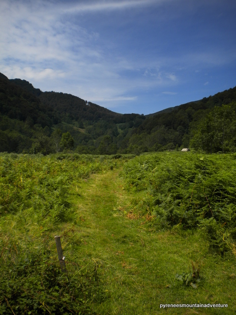
In the distance, Col de la Core

Gentle introduction with some road walking. So lush and green. Friendly shepherd and his partner at the cabane looking after the cattle for the summer.

Day 2. Cabane de la Subra (1499m), Col de Craberous (2382m), Cabane des Espugues (2110m), Col de Pécouch (2462m), Refuge des Estagnous (2245m)   
Distance 10km. Ascent 1386m
Merens horse


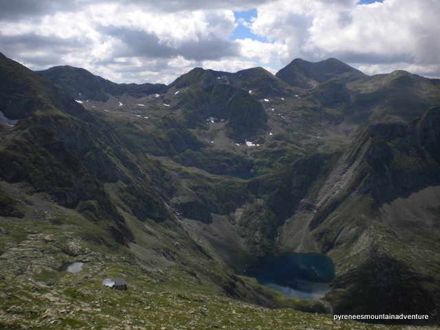
 Col de Pécouch, looking towards Refuge Estagnous and Lac Rond.


Great day. Marmot watching a highlight! Merens horses as well. Awesome views.

Day 3. Cabane Estagnous (2245m), Mont Valier (2838m), Cabane Estagnous (2245m), Etang Long (2125m), Col de la Clauere (2382m), Cases de Bonabe (1400m), Port/Col de Salau (2087m)
Distance 18km. Ascent 1562m
Early morning view from the col before the Mont Valier summit
Lac Rond
Ascent of Mont Valier without full pack. Great views. The blue of Lac Rond is unreal. Some snow on approach to Spanish border. See herd of isards from col, a golden eagle and many vultures. Route markings less clear in Spain.
N.B. A long day. An alternative would have been to cut out the ascent of Mont Valier. Another alternative would be to keep the ascent of Mont Valier and camp just over the Spanish border. This would shorten day 3 and day 4 could be cut as well (see below). There is the option to stay at the refuge.

Day 4. Port/Col de Salau (2087m), Salau (850m), Seix (500m)
Distance 21km. Ascent 0m
Early morning light looking into Spain from Col de Salau
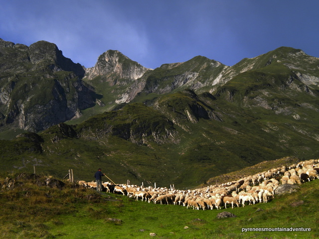
Shepherd herding his sheep
Great light this morning. Passed shepherds herding sheep.
N.B. Route includes 14km of road walking between Salau to Seix beside River Salat. Pleasant enough, but it might have been better to finish at Salau, where there was a nice café, and arrange transport to Seix.


Interested in summer treks like this? Take a look at what Pyrenees Mountain Adventure has to offer here.

There is more information about the Duke of Edinburgh award here.

"Thousands of tired, nerve-shaken, over-civilized people are beginning to find out that going to the mountains is going home; that wildness is a necessity..."  John Muir, 1898